 |
| Vehicles aren't allowed, but you can hike a one-mile section of the 1917 Pershing Highway. (Photo credit: Gerri Bauer) |
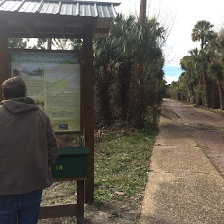
 |
| A sign at the trailhead explains the history of the road once known as Pershing Highway. (Photo credit: Gerri Bauer) |
We're super-sized in so many ways in our modern lives. A giant, single-serve soft drink comes close to the size of a whole bucket used to haul water back in the day. Okay, that's an exaggeration. But serving sizes are, to me, the most obvious sign of our gluttony for bigger, better, more, more, more.
I never considered highways as testaments to the oversizing of our culture. Yet one close look at the 1917 Pershing Highway archaeological site makes me think otherwise.
What a narrow strip of a road. Certain 21st century vehicles would hang off its edges. The tiny-car movement I noticed in recent years seems to have dwindled, no pun intended. In my region, at least, I see far more large pickups and SUVs than I do small cars.
Automobiles were basically one size when Florida inmates built the Pershing Highway, part of which is now an interpretive trail between DeLand and Daytona Beach. Using the bench in the first photo for scale, you can see how narrow the brick roadway is.
In its heyday, the highway was a marvel and technical achievement that served as the main route between the two cities. Before the road connected them, a trip from one to the other could take an entire day. Even though we call it a highway today, in its time it was simply known as either the DeLand Road or the Daytona Road, depending on which way you were traveling.
Think for a minute, what it must have been like to travel the brick paved road in the 19-teen years. Nothing but a slim brick path across sandhills, tangled hammocks, and wetlands. No street lights, traffic signals, gas stations or convenience stores.
The signage at the trail's entrance says the "pea gravel" concrete on each side of the brick was added in the 1920s, likely to allow two cars to pass one another. The initial road was one-lane. Even widened, it remained unlighted. A trip at night must have been a lonely journey through a densely wooded, unpopulated area. The highway still looks isolated today.
The road that appears so desolate to me was a sign of progress in the early days. So much so, that it was featured on Volusia County's 1917 license plates, according to author Ronald Williamson in his excellent book, Volusia County's West Side: Steamboats & Sandhills (History Press, 2008). The book is a collection of history-focused columns Williamson wrote as a journalist. In the article about Pershing Highway, he says the old road was uncovered when wildfires burned through the region in 1998.
Before that, vegetation had swallowed and hid this vestige of an earlier time. Today, you can hike a one-mile section known as the Pershing Highway Interpretive Trail. The trail is part of what is now Tiger Bay State Forest.
Named after World War I General John Pershing, the highway was abandoned in 1947. Adjacent U.S. 92 made for much easier traveling. You can see the parallel roadways in the third photo in this post.
I'm far from an expert on automobiles, but the cars of the late 1940s had to be boat-like in comparison to vehicles of the late teens and early 1920s. So, too, the difference between narrow Pershing Highway and four-lane U.S. 92.
Even the grassy median on the modern highway is wider than the old road. Both are dwarfed by roads and bridges being constructed in the 21st century. Size marches on.
 |
| The old highway was abandoned when U.S. 92, seen behind the sign, opened in the 1940s. (Photo credit: Gerri Bauer) |
